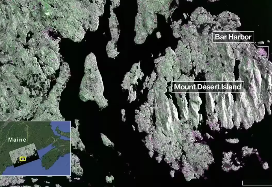
NASA and ISRO have unveiled the first radar images captured by their joint Earth-observing satellite, NISAR (NASA-ISRO Synthetic Aperture Radar). Launched on July 30, 2025, NISAR is equipped with advanced L-band and S-band radar systems, offering unprecedented insight into the planet’s dynamic surface. The initial images, taken in August, showcase remarkable details of dense forests, wetlands, farmland patterns, and urban areas, demonstrating the satellite’s potential for monitoring ecosystems, agriculture, and natural disasters.
Dual-band radar delivers unmatched Earth observation
NISAR is the first satellite to carry both L-band and S-band radars, combining complementary capabilities for high-resolution imaging. NASA’s L-band radar penetrates dense forest canopies, measures soil moisture, and detects subtle land movements such as ice shifts, landslides, and tectonic activity. ISRO’s S-band radar is highly sensitive to smaller vegetation, making it ideal for tracking crops, grasslands, and ecological changes.
Together, the dual-band approach allows NISAR to capture both natural and human-altered landscapes with exceptional clarity, providing valuable data for environmental research, agricultural monitoring, and disaster preparedness.
On August 21, NISAR’s L-band radar imaged Maine’s Mount Desert Island, revealing forests, water bodies, urban infrastructure, and narrow waterways with striking clarity. Magenta areas indicated built environments, while green represented vegetation. Two days later, northeastern North Dakota was captured, highlighting forests, wetlands, and agricultural fields, including circular center-pivot irrigation plots. These images clearly differentiate cropland, pastures, natural vegetation, and human settlements, demonstrating NISAR’s capability to monitor land use, seasonal changes, and ecological health.
Supporting science, climate studies, and disaster response
The high-resolution radar data enables precise tracking of deforestation, wetland loss, crop growth, and land degradation. NISAR also provides early warning capabilities for natural disasters such as earthquakes, landslides, and floods, allowing timely action to protect lives and infrastructure. Continuous global datasets from NISAR will support climate change research and long-term environmental monitoring.
The mission reflects years of technical collaboration between NASA and ISRO, including spacecraft design, radar engineering, and global ground-station support. NASA contributed the L-band radar, reflector, and communication subsystems, while ISRO provided the S-band radar and spacecraft bus. Science operations are scheduled to begin in November 2025, and NISAR is expected to deliver ongoing high-quality radar imagery, revolutionizing our understanding of Earth’s land, ecosystems, and agricultural systems.
Also read: Viksit Workforce for a Viksit Bharat
Do Follow: The Mainstream formerly known as CIO News LinkedIn Account | The Mainstream formerly known as CIO News Facebook | The Mainstream formerly known as CIO News Youtube | The Mainstream formerly known as CIO News Twitter |The Mainstream formerly known as CIO News Whatsapp Channel | The Mainstream formerly known as CIO News Instagram
About us:
The Mainstream formerly known as CIO News is a premier platform dedicated to delivering latest news, updates, and insights from the tech industry. With its strong foundation of intellectual property and thought leadership, the platform is well-positioned to stay ahead of the curve and lead conversations about how technology shapes our world. From its early days as CIO News to its rebranding as The Mainstream on November 28, 2024, it has been expanding its global reach, targeting key markets in the Middle East & Africa, ASEAN, the USA, and the UK. The Mainstream is a vision to put technology at the center of every conversation, inspiring professionals and organizations to embrace the future of tech.


